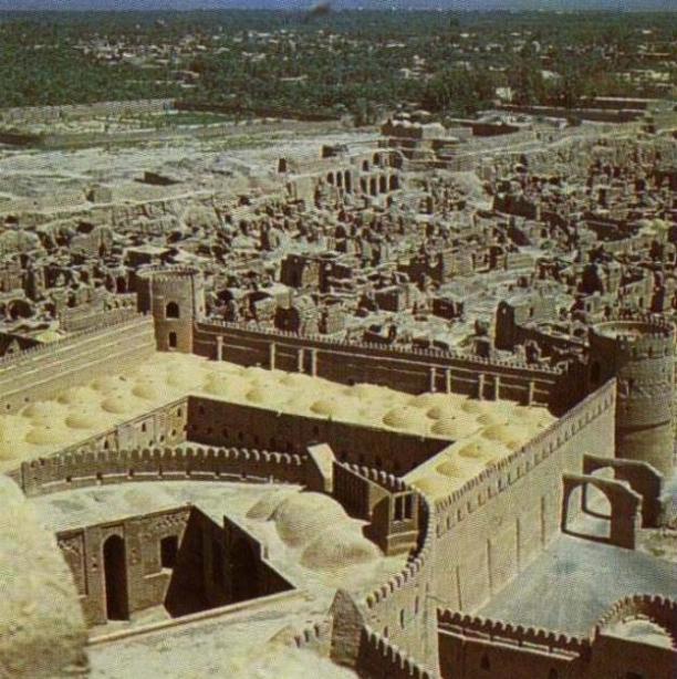
Arge Bam

Bam is located 193 Kms, to the southeast of Kerman in the plain, between the Jebal-e-Barez and Kabudi Mountains, on the Silk Road. The oldest sign of civilization are found in the Bidroun hills located 10 Kms to the west of the city dating back to 4th millennium BC. People have lived in Bam and its vicinity from 6,000 years ago. In ancient times, people lived in a citadel which is now known as Arg-E-Bam. Arg-e-Bam is considered to be the biggest and most beautifull mud-brick complex in the world dating back to Ashkani era. Arg, admeasuring 6 sq., Kms, is located on a 61-meter high stone hill.
Arg-e-Bam is associated with many legendary accounts most of which involve Bahman Pour Grashasb, who was the Achaemenian who lived in Iran circa 312 BC., during the time of Alexander the not so great. . However, most of the historians refer to the story of "Haftvad" in the Shahnameh, or "Haptanbad" in the Karnamak-e-Ardashir-e-Papkan, a historically true story of the foundation of Bam. If so, this date goes back to the late, or mid, Parathion period although a thorough scientific and archeological inspection of the site is still needed. There are some signs and indications like some Parathion coins found here - which make it a safe guess to assume that the nucleus part of the town and the citadel belonged to the Parthian period in its original form. After Haftvand was defeated by Ardashir, the victorious king destroyed the main citadel in the fortress and built a fire-temple in it instead, which, it is believed, was turned into the existing main observation tower and the Char-Fasl building in the Islamic period. In any event, as one walks through the ruins of this ancient town they can observe the imprints of history on each corner and walk through a pass-way where people of centuries have walked through. The poet Khayyam recites:
Think, in this batter'd Carvanserai Whose Doorways are alternate Night and Day How Sultan after Sultan with his romp Abode his Hour or two, and went his way
The buildings inside are made from clay, bricks and clay mortar. There is only one entrance, which is similar to the Sassanid era's arches. The towers at the sides and the vestibule are thought to have been added during the Safavid era . Relics of another gate can be seen in the northern section of the Arg. Arg has a main gate from the south to the ruler's palace, two parallel passes and a few rows of shops on the eastern and western sides. 60 meters of the main road to the market was roofed and a portion of its road was paved with stones. The better-known places of Arg-e-Bam are: a public bath, a traditional gymnasium, a garrison, a stable, a jail, a four-season building (the governing palace), and the governor's house.
Up until Friday December 26,2003 Arg-e-Bam was considered one of the best preserved historical sites in the world, however, an Earthquake shock this anceint town and destroyed much of Bam's historic landmark. Television images showed the highest part of the fort — including its distinctive square tower — crumbled like a sand castle down the side of the hill, though some walls still stood, but as much as 70% of the city was destroyed in this insident. (Local officials estimated that up to 30,000 lost their lives as a result of the EQ, may they all have our blessings).
The reconstruction of the Bam Citadel is underway, and although the officials are working very slow, they are trying to be as accorate as possible in reconstructing this historical site.
Map of the Location of Arg-E-Bam in Iran:
http://activistchat.com/albums/alargebam/argebam23.sized.jpg
See Pictures of Arg-E-Bam:
http://activistchat.com/albums/alargebam/argebam1.sized.jpg
http://activistchat.com/albums/alargebam/argebam8.sized.jpg
http://activistchat.com/albums/alargebam/argebam17.jpg
http://activistchat.com/albums/alargebam/argebam20.jpg
http://activistchat.com/albums/alargebam/argebam21.sized.jpg
http://activistchat.com/albums/alargebam/argebam10.jpg
http://activistchat.com/albums/alargebam/argebam11.thumb.jpg
http://www.iranianlanguages.com/pictures/sites/images/p26.jpg
Photos from the Scene of the Earth Quake:
http://activistchat.com/albums/quake/en_20031226_3_12.thumb.jpg
http://activistchat.com/albums/quake/en_20031226_3_14.thumb.jpg
http://activistchat.com/albums/quake/en_20031226_3_4.thumb.jpg
posted by M at 7:07 PM
![]()
![]()


<< Home