Tuesday, December 30, 2003

Persian History at a Glance

(This summery is for those who find the persian history too complicated)
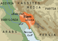
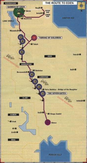
Archaeological studies during the first half of the twentieth century indicate that as early as 10,000 BC, tribes lived on the southern shores of the Caspian, one of the few regions of the world, which according to scientists escaped the Ice Age. They were probably the first men in the history of mankind to engage in agriculture and animal husbandry. It was they and others who spread out shortly afterwards along the Zagros Mountains in central Iran and founded the first centers of civilization in the land (Elam).
The history of settlement in the plateau of Iran from New Stone Age till migration of Aryans is not yet very clear. But there are reliable evidences, which indicate that Iran has been inhabited for a very long time now. Settlement centers have emerged either close to water resources like springs and rivers or completely close to Alborz and Zagross Mountains. The most important centers of this kind are: Sialk Tappeh (hill) in Kashan, Hezar Tappeh in Damghan, Torang Tappeh in Gorgan, Hasanlu Tappeh in Azerbaijan, Marlik Tappeh in Roodbar, and Susa (Shoosh) in Khuzestan.Some vestiges have been discovered by archeological excavations in these civilization centers, the antiquity of which dates back to the 5th millennium BC.
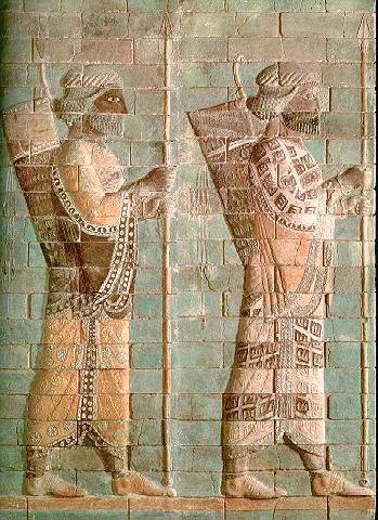
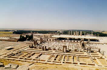
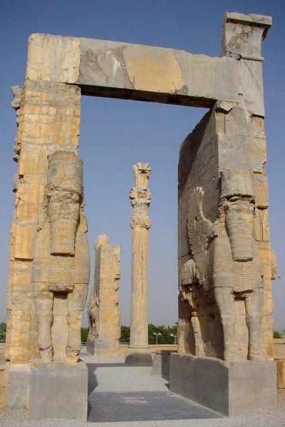
Migration of Aryan clans to the plateau of Iran began since 2nd millennium BC.Out of these tribes, Parthians dwelled in Khorasan, Medes in the west, and Parsees resided in the south of Iran. The Median Empire rose in Hegmataneh (Ekbatan), presently called Hamadan.The Achaemenid established the first great Iranian Empire after defeating the Medians and conquest of their capital. The limits of the Achaemenian territory in the reign of Dariush I (522-485BC.), extended from the Plain of Sand River in the east to the borders of Greece at the west. Passargad and Persepolis are the vestiges of this period and are amongst the most important historical places as well as the significant tourism attractions of Iran. Every year, thousands of tourists from four corners of the world visit these sites.
After the decline of the Achaemenian dynasty, and destruction of Persepolis by Alexander, his successors (Solookis) dominated over Iran for a short period of time. During this period, the interaction of Iranian and Hellenic cultures took place. Around the year 250 BC, the Parthians, who were one of Aryan tribes as well as horse riders, advanced from Khorasan towards the west and southwest and founded their empire over Iran plateau in Teesfoon.This empire survived till the year 224 AD. The Sasanids, after defeating the last Parthian king in 225 AD, founded a new empire, which lasted till mid 7th century AD. The ancient period of Iran (Persia), regarding its political, social and cultural characteristics, is one of the most magnificent epochs of heritage and historical buildings in Persepolis, Pasargad, Shoosh, Shooshtar, Hamedan, Marvdasht (Naghsh-e-Rostam), Taghbostan, Sarvestan, and Neishabour that are really worth-visiting.
Emergence and influence of Islam in Iran happened in early 7th century AD. after the decline of Sasanid empire. Since then, new era began in the history of Iran which caused great fundamental evolution in social, political, religious, governmental, and public conditions of the country. Iranians, who were very disappointed with existing social and economic inequality in the time of Sasanids, accepted Islam very warmly and tried to expand it and enrich its cultural magnanimity quite rapidly.
In spite of accepting Islam, Iranians never covered up their opposition against dominance of Omavi and Abbasi Caliphs and their tyrannies and founded many autonomous movements to confront them. On the other hand, Caliphs, for neutralizing and suppressing these Iranian movements, which were based on partisanship of the Islam and Prophet’s family and establishment of a government on the basis of Imamat, tried to support non-Iranian forces. Due to continuity of these wars of attrition among local governors, their power was exhausted, so the ground for dominance of stranger tribes of Central Asia, like Saljooghi Turks, Mongols, and Taymoorians, was brought about. In Safavid time, the second great Iranian Empire was founded and Shiia religion, disciples of which were seriously limited till then, was formalized. The dynamic nature of Shiia religion and its political and social commitments firmly safeguarded the independence and national identity of Iran against Ottomans’ assaults (Turky). Iran, as a new political and religious power, could once again hoist the flag of resistance against a very powerful empire that was the claimant of supremacy of Islamic world. With the decline of Safavid, Afsharieh and then Zandieh took the throne. After Zandieh government, the time of Qajarieh began during which the influence of foreign powers in internal affairs of Iran expanded. Meanwhile, social movements of Tobacco, Constitutional Revolution, and Forest Uprising headed by Mirza Koochak Khan-e-Jangali, Sheikh Mohammad Khiabani revolt, and a lot of other brave reform movements happened. In Pahlavi time, Oil Industry Nationalization Movement intrigued the movement of June 5th 1963 and other autonomous movements that gave rise to the Islamic Revolution under the leadership of Late Ayatollah Khomeini in 1979.

Picture of Sialk Tappeh (hill):
http://www.bestirantravel.com/images/sights/kashan/sialktapeh.jpg

Artifacts from Elamid time:
http://iranchamber.com/history/elamite/images/silver_vase3000bc.jpg
http://iranchamber.com/history/elamite/images/marlik_gazelles.jpg

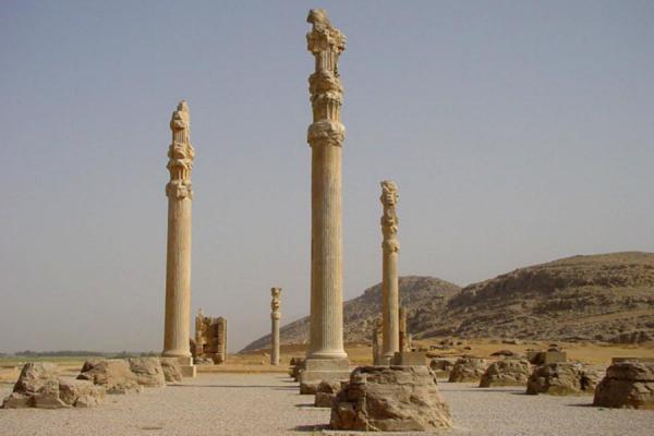
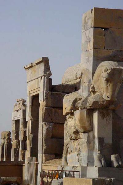
Pictures of Persepolis:
http://www.bamjam.net/Iran/images/Perse07.jpg
http://www.bamjam.net/Iran/images/Perse08.jpg
http://www.traveladventures.org/continents/asia/images/persepolis02.jpg
http://www.traveladventures.org/continents/asia/images/persepolis03.jpg
http://www.traveladventures.org/continents/asia/images/persepolis08.jpg
http://www.shirazcity.org/shiraz/Shiraz%20Information/Sightseeing/images/Persepolis/b13.jpg
http://www.shirazcity.org/shiraz/Shiraz%20Information/Sightseeing/images/Persepolis/b59.jpg
http://www.shirazcity.org/shiraz/Shiraz%20Information/Sightseeing/images/Persepolis/b14.jpg
http://www.shirazcity.org/shiraz/Shiraz%20Information/Sightseeing/images/Persepolis/b69.jpg
http://www.shirazcity.org/shiraz/Shiraz%20Information/Sightseeing/images/Persepolis/b65.jpg

Tomb of Cyrus the Great:
http://www.oznet.net/iran/Tomb.jpg
http://www.iranpix.com/images/01iranpix/ancient_iran/pasargad/01-07-30-4394-iran-persia-pasargad-

Tomb of Darius:
http://www.oznet.net/iran/Daritomb.jpg
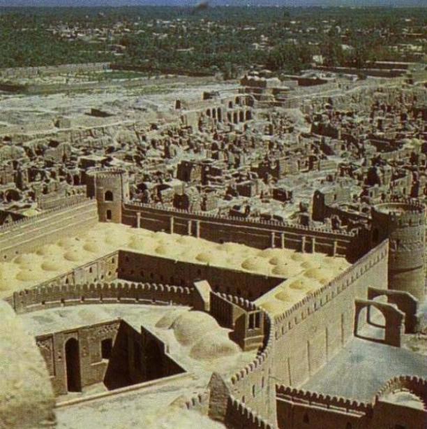
Cidal of Bam:
http://iranianlanguages.com/pictures/sites/images/p26.jpg

Achamanid Artifact found in Hekmatane:
http://iranianlanguages.com/pictures/sites/images/p3.gif
http://iranianlanguages.com/pictures/sites/images/p4.gif

Caspian Sea:
http://iranianlanguages.com/pictures/sites/images/p9.jpg

Ziggurat:
http://www.oznet.net/iran/zigg2.jpg

Susa Cidal:
http://iranianlanguages.com/pictures/sites/images/p23.jpg
http://www.oznet.net/iran/soosh.jpg

Shooshtar:
http://iranianlanguages.com/pictures/sites/images/p22.jpg

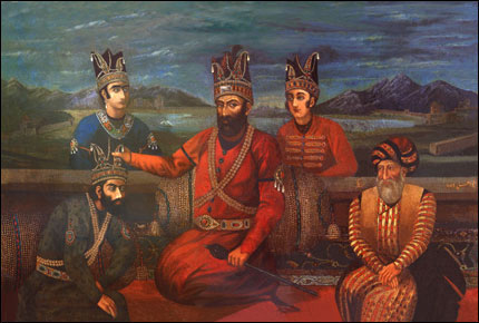
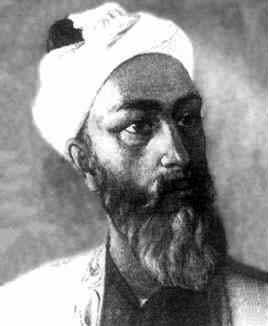
Picture of Nader Shah Afshar:
http://www.iranchamber.com/history/afsharids/images/nader_shah.jpg

Parthian city of Hatra in Northern Mesopotamia:
http://www.mesopotamia.co.uk/time/explore/images/parthian.jpg

A Sasanian silver bowl showing a king hunting:
http://www.mesopotamia.co.uk/time/explore/images/sasanian.jpg

Süleiman I, one of the greatest Ottoman sultans:
http://www.mesopotamia.co.uk/time/explore/images/ottoman.jpg

'Ali Qapu created by Shah Abbas Safavi:
http://isfahan.anglia.ac.uk/aliqapu/aliqap1i.htm

Picture of Reza shah Pahlavi:
http://www.sedona.net/pahlavi/rezashah.jpg

Picture of Mohammad Reza shah Pahlavi and his wife Farah:
http://www.sedona.net/pahlavi/mrpgulf.jpg
http://www.farahpahlavi.org/qindex4.jpg

Picture of Khomeyni:http://i-cias.com/e.o/ill/khomeini.jpg

Monday, December 29, 2003

The Ancient City of Susa (shoosh)


The very first civilization which has ever lived in Iran was The Shoosh Civilization.
8000 years ago, there was a civilization which lived in today's Khoozestan, their name was "Shoosh Civilization," or in English "Susa Civilization." So far this has been reported as the oldest civilization which have ever existed on Earth. By civilization, we mean civilized city government or city state or Empire or Kingdom or any type of local civilized system. The ancient city of Susa is mentioned in Old Testament as the place where prophet Daniel lived. The city name is derived from Shashana, a member of water lily family of flowers, believed to grow in lakes and swamps outside this biblical city in ancient times.
Susa was the capital of a ancient kingdom know is Elam. A kingdom built and ruled by Dravidian people who ruled it from second millennium BCE until late mid-first millennium BCE. Elamite kingdom was destroyed by attacks from Babylonians. Elamite influence spread throughout the southern regions of Iran by their cuneiform writing system, and rock inscriptions. After that Cyrus the Great founded his empire and gained control over Susa. Susa was declared as one of the three capitals of the empire covering the southern regions. When Darius established his rule over the empire, he set out to built the palace of Persepolis in his home state, and later an equally magnificent palace in his favorite city of Susa. It is said that the carving style and shapes of the columns in Susa are similar to Persepolis buildings. The fluted shaped column with flowers at pillars are truly an Achaemenian style in ancient palace buildings. Today we can visit the ruins of this palace built on a hilltop overlooking the modern city of Susa. This style was later used in ancient palaces as far as northern India all the way to Ionian Greece.
Till the beginning of the control by the moslems, Shoosh continued to thrive. In the year 1898 AD, the famous castle of Shoosh was constructed by "Morgan" on the northern part of the Acropol hill. The ancient name of Shoosh was 'Soos' or 'Dasht-e-Soosiana', and later on was changed to Shoosh. The tomb of Profet Daniel is also located in Shooshtar and it can be seen on the western side of the palace hill.
One of the most beuatiful castles in Shooshtar is the Acropol or Shoosh castle which was constructed by a group of French archeologists in the year 1897 AD in the highest region of the city. The design is very similar to the Bastille in France. This castle has been constructed by Dezful artists and by means of bricks obtained from Darius (Dariush) castle and some engraved bricks in the Kific script from Choqazanbil. Valuable and important relics such as the famous statue of Queen Napirasustoon, Hamurabi Code and famed buff earthenware glass of Shoosh with a wild goat drawing have been discovered from the Acropol Hill. It took a period of 15 years to build this structure which stood as a defense fort against the attack of local clans and tribes.


Map of the location of Susa:
http://www.allempires.com/empires/elamite/mapelam.gif

Achamenid's Art Remains in Susa:
http://www.irantourleaders.com/glazedbricks.JPG
http://usitweb.shef.ac.uk/~ema00am/khuzestan/chogha_album/images/07010240.jpg
http://usitweb.shef.ac.uk/~ema00am/khuzestan/chogha_album/images/07010251.jpg
http://usitweb.shef.ac.uk/~ema00am/khuzestan/chogha_album/images/07010253.jpg
http://usitweb.shef.ac.uk/~ema00am/khuzestan/chogha_album/images/11020050.jpg
http://usitweb.shef.ac.uk/~ema00am/khuzestan/chogha_album/images/1102m003.jpg
http://usitweb.shef.ac.uk/~ema00am/khuzestan/chogha_album/images/1102m002.jpg
http://usitweb.shef.ac.uk/~ema00am/khuzestan/chogha_album/images/11020160.jpg

Shooshtar Cidal:
http://www.iranianlanguages.com/pictures/sites/images/p23.jpg
http://www.cpersia.com/assets/other_images/Pic_297.gif
http://www.iranparadise.com/Iran/IMAGES/Khuzistan-FrenchCastelSho.jpg

Chogha Zanbil Cidal in Shoosh(susa): ( I will elaburate more on this site in the near feuture)
http://www.iranestatitra.com/majzoubgasht/images/CHoghazanbil.jpg
http://www.iranparadise.com/Iran/IMAGES/khuzistan-pasargad.jpg
http://usitweb.shef.ac.uk/~ema00am/khuzestan/chogha_album/images/05020110.jpg
http://usitweb.shef.ac.uk/~ema00am/khuzestan/chogha_album/images/07010053.jpg
http://usitweb.shef.ac.uk/~ema00am/khuzestan/chogha_album/images/07010190.jpg
http://usitweb.shef.ac.uk/~ema00am/khuzestan/chogha_album/images/05020520.jpg

Profet Danial's Tomb:
http://www.iranestatitra.com/majzoubgasht/images/Shosh.jpg
http://www.iransebttour.com/Highlights/Images/Khuzestan/Image07.jpg

City Of Shooshtar:
http://www.iranianlanguages.com/pictures/sites/images/p22.jpg
http://www.iransebttour.com/Highlights/Images/Khuzestan/Image09.jpg

Sunday, December 28, 2003

Cuneiform Tablets

Uncovered in the debris of the Treasury were hundreds of clay tablets with inscriptions in Elamite cuneiform. These tablets, originally sundried, were baked in the heat of the immense fire that destroyed the building, so that many were found intact instead of having crumbled to dust long ago. These tablets, written for the most part in Old Persian and its corresponding translations of Elamite and Babylonian, were of great value to the excavators. We learn from them of the presence in Persepolis of skilled workmen from many parts of the empire, of stone-relief and inscription workers from Egypt, goldsmiths from Caria, and ornament makers from Susa. Some tablets also mention the month and year of the reign of either Darius or Xerxes when a particular work was executed and the amount of compensation-either in kind or in money-the workers received. Other tablets bear records of sales, of land deals, of taxes to be paid, or of the amount of money borrowed from the treasury. Finally, some tablets give instructions about how much haoma, the sacred intoxicating drink, could or should be used at a cult service. Some of the examples of the Cuniform tablets are:

Cyrus the Great's Cylinder ( the 1st charter of human rights):
http://www.livius.org/a/1/mesopotamia/cyrus_cilinder.JPG
Achamenian's Ganjnameh ( the Treasure Inventory) in Hamedan:
http://www.mojesafar.com/IMAGES/places/ganjnameh.jpg

Friday, December 26, 2003

Arge Bam


Bam is located 193 Kms, to the southeast of Kerman in the plain, between the Jebal-e-Barez and Kabudi Mountains, on the Silk Road. The oldest sign of civilization are found in the Bidroun hills located 10 Kms to the west of the city dating back to 4th millennium BC. People have lived in Bam and its vicinity from 6,000 years ago. In ancient times, people lived in a citadel which is now known as Arg-E-Bam. Arg-e-Bam is considered to be the biggest and most beautifull mud-brick complex in the world dating back to Ashkani era. Arg, admeasuring 6 sq., Kms, is located on a 61-meter high stone hill.
Arg-e-Bam is associated with many legendary accounts most of which involve Bahman Pour Grashasb, who was the Achaemenian who lived in Iran circa 312 BC., during the time of Alexander the not so great. . However, most of the historians refer to the story of "Haftvad" in the Shahnameh, or "Haptanbad" in the Karnamak-e-Ardashir-e-Papkan, a historically true story of the foundation of Bam. If so, this date goes back to the late, or mid, Parathion period although a thorough scientific and archeological inspection of the site is still needed. There are some signs and indications like some Parathion coins found here - which make it a safe guess to assume that the nucleus part of the town and the citadel belonged to the Parthian period in its original form. After Haftvand was defeated by Ardashir, the victorious king destroyed the main citadel in the fortress and built a fire-temple in it instead, which, it is believed, was turned into the existing main observation tower and the Char-Fasl building in the Islamic period. In any event, as one walks through the ruins of this ancient town they can observe the imprints of history on each corner and walk through a pass-way where people of centuries have walked through. The poet Khayyam recites:

Think, in this batter'd Carvanserai Whose Doorways are alternate Night and Day How Sultan after Sultan with his romp Abode his Hour or two, and went his way

The buildings inside are made from clay, bricks and clay mortar. There is only one entrance, which is similar to the Sassanid era's arches. The towers at the sides and the vestibule are thought to have been added during the Safavid era . Relics of another gate can be seen in the northern section of the Arg. Arg has a main gate from the south to the ruler's palace, two parallel passes and a few rows of shops on the eastern and western sides. 60 meters of the main road to the market was roofed and a portion of its road was paved with stones. The better-known places of Arg-e-Bam are: a public bath, a traditional gymnasium, a garrison, a stable, a jail, a four-season building (the governing palace), and the governor's house.
Up until Friday December 26,2003 Arg-e-Bam was considered one of the best preserved historical sites in the world, however, an Earthquake shock this anceint town and destroyed much of Bam's historic landmark. Television images showed the highest part of the fort — including its distinctive square tower — crumbled like a sand castle down the side of the hill, though some walls still stood, but as much as 70% of the city was destroyed in this insident. (Local officials estimated that up to 30,000 lost their lives as a result of the EQ, may they all have our blessings).
The reconstruction of the Bam Citadel is underway, and although the officials are working very slow, they are trying to be as accorate as possible in reconstructing this historical site.

Map of the Location of Arg-E-Bam in Iran:
http://activistchat.com/albums/alargebam/argebam23.sized.jpg

See Pictures of Arg-E-Bam:
http://activistchat.com/albums/alargebam/argebam1.sized.jpg
http://activistchat.com/albums/alargebam/argebam8.sized.jpg
http://activistchat.com/albums/alargebam/argebam17.jpg
http://activistchat.com/albums/alargebam/argebam20.jpg
http://activistchat.com/albums/alargebam/argebam21.sized.jpg
http://activistchat.com/albums/alargebam/argebam10.jpg
http://activistchat.com/albums/alargebam/argebam11.thumb.jpg
http://www.iranianlanguages.com/pictures/sites/images/p26.jpg

Photos from the Scene of the Earth Quake:
http://activistchat.com/albums/quake/en_20031226_3_12.thumb.jpg
http://activistchat.com/albums/quake/en_20031226_3_14.thumb.jpg
http://activistchat.com/albums/quake/en_20031226_3_4.thumb.jpg

Who Were the Magi?

Most of what we associate with the "Magi" is from early church traditions. Most have assumed there were three of them, since they brought three specific gifts (but the Biblical text doesn't number them). They are called "Magi" from the Latinized form of the Greek word magoi, transliterated from the Persian, for a select sect of priests. (Our word "magic" comes from the same root.)
As the years passed, the traditions became increasingly embellished. By the 3rd century they were viewed as kings. By the 6th century they had names: Bithisarea, Melichior, and Gathaspa. Some even associated them with Shem, Ham and Japheth--the three sons of Noah--and thus with Asia, Africa, and Europe. A 141h century Armenian tradition identifies them as Balthasar, King of Arabia; Melchior, King of Persia; and Gasper, King of India.
The ancient Magi were a hereditary priesthood of the Medes (known today as the Kurds) credited with profound and extraordinary religious knowledge. After some Magi, who had been attached to the Median court, proved to be expert in the interpretation of dreams, Darius the Great established them over the state religion of Persia. (2) (Contrary to popular belief, the Magi were not originally followers of Zoroaster. (3) That all came later.)It was in this dual capacity, whereby civil and political counsel was invested with religious authority, that the Magi became the supreme priestly caste of the Persian empire and continued to be prominent during the subsequent Seleucid, Parthian, and Sasanian periods. (4)
Later on the Magi hugely influenced Jews and since the Roman conquered Jerusalem in 63 B.C., the Magi influence slipt in to thier customs as well. In the Bible (Matthew 2), the Magi are known as the The "wise men from the East" who came to adore Jesus in Bethlehem .
In Persia much of the evidence from the acitvities of Magi comes from the Greek historian Herodotus. In his books Herodotus states that the Magi provided priests for Persia, and, regardless of dynastic vicissitudes, ever kept up their dominating religious influence. He also mentions,The Magi are a very peculiar race, different entirely from the Egyptian priests, and indeed from all other men whatsoever. The Egyptian priests make it a point of religion not to kill any live animals except those which they offer in sacrifice. The Magi, on the contrary, kill animals of all kinds with their own hands, excepting dogs and men. They even seem to take a delight in the employment, and kill, as readily as they do other animals, ants and snakes, and such like flying or creeping things.
After the downfall of Assyrian and Babylonian power, the religion of the Magi held sway in Persia. Cyrus completely conquered the sacred caste; his son Cambyses severely repressed it. The Magians revolted and set up Gaumata, their chief, as King of Persia under the name of Smerdis. He was, however, murdered (521 B.C.), and Darius became king. This downfall of the Magi was celebrated by a national Persian holiday called magophonia (Her., III, lxiii, lxxiii, lxxix). Still the religious influence of this priestly caste continued throughout the rule of the Achaemenian dynasty in Persia (Ctesias, "Persica", X-XV); and is not unlikely that at the time of the birth of Christ it was still flourishing under the Parthian dominion. Strabo (XI, ix, 3) says that the Magian priests formed one of the two councils of the Parthian Empire.
The visit of the Magi took place after the Presentation of the Child in the Temple (Luke 2:38). No sooner were the Magi departed than the angel bade Joseph take the Child and its Mother into Egypt (Matthew 2:13). From Persia, whence the Magi are supposed to have come, to Jerusalem was a journey of between 1000 and 1200 miles. Such a distance may have taken any time between three and twelve months by camel. Besides the time of travel, there were probably many weeks of preparation. The Magi could scarcely have reached Jerusalem till a year or more had elapsed from the time of the apperance of the star. St. Augustine (De Consensu Evang., II, v, 17).
The philosophy of the Magi, erroneous though it was, led them to the journey by which they were to find Christ. Magian astrology postulated a heavenly counterpart to complement man's earthly self and make up the complete human personality. His "double" (the fravashi of the Parsi) developed together with every good man until death united the two. The sudden appearance of a new and brilliant star suggested to the Magi the birth of an important person. They came to adore him - i.e., to acknowledge the Divinity of this newborn King (vv. 2, 8, 11). Some of the Fathers (St. Irenaeus, "Adv. Haer.", III, ix, 2; Progem. "in Num.", homil. xiii, 7).

Pictures of Magi:
http://www.ldolphin.org/magi.jpg


Wednesday, December 24, 2003

The Silk Road

The Silk road is the name for the trade route between the Mediterranean Sea and China. The first users of the road must have lived in the first half of the first millennium BCE, but the name 'Silk road' dates from the first century BCE. Its most famous traveler lived more than twelve hundred years later: Marco Polo of Venice (1254-1324). This road is considered to be one of the World's oldest and most historical trade route which has largly influenced the cultures of China, Centeral Asia and Eastern Europe.
The western end of the trade route appears to have developed earlier than the eastern end, principally because of the development of the the empires in the west, and the easier terrain of Persia and Syria. The Persian Empire was in control of a large area of the Middle East, extending as far as the Indian Kingdoms to the east. Trade between these two neighbours was already starting to influence the cultures of these regions. At the beginning of the sixth century BCE, the trade route started in Babylon, from where it passed through Opis/Ctesiphon (Baghdad) and Ecbatana (Hamadân) and modern Sâveh, the place where Marco Polo was to see the tombs of the three Magi who had visited Jesus of Nazareth. Whatever the historical value of the story of the Magi, they must have traveled along the Silk road. From Sâveh, the road continued to Rhagae (Tehrân), the religious capital of ancient Media. Further to the east, it passed through Parthia and reached Hecatompylus (near Dâmghân) and Susia (Tûs near Mashad). Here the road forked. The southern branch went through the Arian capital Artacoana (Herât) to Kapisa (Kandahâr) in Arachosia, and from there either to the southeast to the Lower Indus or to the northwest to Gandara (the valley of the Kabul) and the Punjab. The northern branch went from Susia through the Karakum desert, passing along the oasis Margiana (Mary or Merv) and the Scythian tribes along the Amudar'ya, to Maracanda (Samarkand) in Sogdiana or to Bactra (Balkh, near modern Mazâr-e Sharîf) and Drapsaca (Kondûz). Here, lapislazuli could be found, a precious article that was much appreciated in Babylonia and Assyria. Other articles that were traded were horses and camels.
Much of the region is taken by the Taklimakan desert, one of the most hostile environments on our planet. There is very little vegetation, and almost no rainfall; sandstorms are very common, and have claimed the lives of countless people. The locals have a very great respect for this `Land of Death'; few travellers in the past have had anything good to say about it. It covers a vast area, through which few roads pass; caravans throughout history have skirted its edges, from one isolated oasis to the next. The climate is harsh; in summers the tempreture gets as high as 50 degrees Celsius, and in winters the temperatures dip below minus 20 degrees.
The Silk Road, after a long period of hibernation, has been increasing in importance again recently.
The fight of man against the desert, one of the biggest problems for the early travellers, is finally gaining ground. There has been some progress in controlling the progress of the shifting sands, which had previously meant having to resite settlements. The construction of roads around the edges of the Taklimakan has eased access, and the discovery of large oil reserves under the desert has encouraged this development. The area is rapidly being industrialised, and Urumchi, the present capital of Xinjiang, has become a particularly unprepossessing Han Chinese industrial city.

The Map of the Silk Road:
http://www.livius.org/a/1/maps/silk_road_map.gif

Pictures of the Silk Road:
http://www.ess.uci.edu/~oliver/silk/olly6.jpg
http://www.ess.uci.edu/~oliver/silk/olly1.jpg
http://www.silkroadadventures.net/images/Singing%20dune%201..jpg

The Ancient City of Ecbatana


Hamadan (Ecbatana) is situated 400 km south west of Tehran, in the Zagros mountains of central-west Persia at the base of the eastern slope of the Alvand range. It was capital of the Median empire, summer capital of the Achaemenids, and satrapal seat of the province of Media from Achaemenid to sassanid times.
The poet Ferdowsi says that Ecbatana was build by King Jamshid. According to Herodotus the Greek Historian Ecbatana was founded by Deioces, the legendary first king of the Medes. Ancient writers say the city had seven walls, each of which had a different color, and that the inner wall was covered with gold. Later on another Greeks historian Polybius of Megalopolis offers probably the best available description of the city (World history 10.27.5-13). He writes that the city was richer and more beautiful than all other cities in the world. Semiramis, an Assyrian queen, built a gorgeous palace here in 800 BC. In 546 BC Cyrus the Great, a member of the Persian Achaemenid dynasty,overthrow the Median Empire and later conquered Lydia and brought Croesus and his wealth to Ecbatana. According to the Greek historian Xenophon of Athens (c.430-c.355), Ecbatana became the summer residence of the Achaemenid kings (Anabasis 3.5.15).
Alexander visited the city twice. In the spring of 330 B.C.E., following the conquest of Persepolis and Pasargadae, he marched in pursuit of Darius to Ecbatana, where he captured the Persian treasury. Parmenio, Alexander's second-in-command, was left there to oversee communications but was assassinated shortly afterwards on Alexander's orders. Before continuing east, Alexander stored the captured Persian treasure in Ecbatana and looted much of the gold and silver decoration of the palace. During Alexander's second visit in the autumn of 324 B.C.E., his closest friend, Hephaestion, died there. Arrian records, though with skepticism, that Alexander in his sorrow had the Temple of Asclepius torn down. Aelian claims that the city and its walls were pulled down. The reference may be to the citadel walls since Polybius explicitly asserts that the city itself had no walls.
In December 522, the Median rebel Phraortes reoccupied Ecbatana and made it his capital; he was defeated, however, by the Persian king Darius I the Great (May 521). He celebrated this event with a large relief and an inscription along the road between Babylon and Ecbatana (the famous Behistun inscription). Greek sources mention temples dedicated to the goddess Aenê (probably Anahita) and the goddess of healing, which the Greeks called Asclepius. This shrine was destroyed by the Macedonian king Alexander the Great, who overthrew the Achaemenid empire, because the god had allowed his friend Hephaestion to die in Ecbatana (324).
Later, Ecbatana was one of the capitals of the Seleucid and the Parthian empire, sometimes called Epiphaneia and also Hecmatane.
The modern city of Hamadan is built over the mound of ancient Ecbatana, making it all but impossible to excavate the ruins of this fabulously wealthy capital city ( similar to the situation in Athenes).

Picture of the lion erected by Alexander as a memorial to Hephaestion:
http://www.caravanserai-tours.com/images/iran/Hamadan_Stone_Lion.jpg

The Golden Rhyton found in Ecbatana:
http://www.cpersia.com/assets/other_images/pic_344.gif
http://www.iranembassy.hu/p049_large.jpg

The Behiston Relief Built by Daruis I:
http://www.livius.org/a/1/iran/behistun_photo.jpg
http://www.livius.org/a/1/iran/behistun.jpg

Monday, December 22, 2003

Adam & Eve were Persian!

Ten miles from the sprawling Iranian industrial city of Tabriz, to the northwest of Tehran, says British archaeologist David Rohl, he has found the site of the Biblical garden . . . "As you descend a narrow mountain path, you see a beautiful alpine valley, just like the Bible describes it, with terraced orchards on its slopes, crowded with every kind of fruit-laden tree," says Rohl, a scholar of University College, London, who has just returned from his third trip to the area, where mud brick villages flourish today.
“The Biblical word gan (as in Gan Eden) means `walled garden,’ ” Rohl continues, "and the valley is indeed walled in by towering mountains." The highest of these is Mt. Sahand, a snow-capped extinct volcano that Rohl identifies as the Prophet Ezekiel’s Mountain of God, where the Lord resides among `red-hot coals’ (Ezekiel 28:11-19). Cascading down the once-fiery mountain, precisely echoing Ezekiel, is a small river, the Adji Chay (the name of which also translates in local dialect as ‘walled garden’). The locals still hold the mountain sacred, Rohl says, and attribute magical powers to the river’s water.
What made Rohl look in this location in the first place? One factor was that he read about it in ancient Sumerian cuneiform clay tablets held by the Museum of the Orient in Istanbul. The other factor was the work of the late, little-known British scholar Reginald Walker. The ancient tablets described a 5,000 year-old route to Eden. He has been researching the location since the late 1980’s through academic documents.
In April 1997 Rohl did something very remarkable to prove his point. He set out from the Iranian town of Ahwaz, near the northern tip of the Persian Gulf, with only his jeep driver for company. According to the article:

They traveled north toward Kurdistan through what Rohl calls `lawless’ terrain, trusting to luck to avoid the various guerrilla factions active in the region. Rohl followed a route, documented in the Sumerian cuneiform epic `Enmerkar and the Lord of Aratta,’ supposedly taken 5,000 years earlier by an emissary of the Sumerian priest-king of Uruk. The emissary had been dispatched to Aratta, on the plain of `Edin’ – known to Sumerians as a land of happiness and plenty – to obtain gold and lapis lazuli to decorate a temple that Enmerkar was building in Uruk. The cuneiform epic describes the dutiful emissary’s three-month trek on foot via seven passes through the Zagros Mountains, to the foothills of Mt. Sahand – the southern edge of Rohl’s Eden – and his successful procurement of the required valuable.
Rohl believes . . . the ancient Sumerians, Babylonians, and Assyrians all knew of an earthly paradise that had once lain beyond what they called the Seven Heavens. For them, Eden was still very much an earthly place. Only later Judeo-Christian tradition bestowed heavenly status on it.


The Garden described in the Bible places the headwaters of four rivers in it: the Tigris, the Euphrates, the Gihon, and the Pishon. Obviously, the Tigris and Euphrates are well-known rivers, but the other two have been real problems in the past. Rohl has identified them as the Araxes and Uizhun, which puts the headwaters of all four rivers in his Eden. Interestingly, the Uizhun, Rohl's equivalent to the Pishon which the Bibles identifies with gold, is known locally as the Golden River, and meanders between ancient gold mines and lodes of lapis lazuli.
Making his case even stronger, Rohl says that he has found the "Land of Nod" which the Bible describes as "East of Eden." Nod was Cain's place of exile after the murder of his brother Abel. Today the area is called "Noqdi."
But it doesn't end there because a few kilometers south of Rohl's Nod, at the head of a mountain pass, lies the sleepy town of Helabad. Formerly it was known as "Kheruabad," which means "settlement of the Kheru people." He believes that this could be a permutation of the Hebrew word keruvim that is translated as "Cherubs." These people were a tribe of fearsome warriors whose token was an eagle or falcon.
And if this isn't enough to get your attention yet, he has also found what he believes to be the biblical "Land of Cush." No, it's not located down in Egypt as scholars have declared for centuries. It's just north of the Adji Chay river valley and over the Kusheh Daugh - the Mountain of Kush. One of the four rivers described above winds through it.
Modern scholars have argued that the Genesis stories were just myths and should be looked upon in an allegorical sense. Rohl's discovery is now essentially seeking to push back the start of history all the way to the beginning of the Book of Genesis. Since the Bible scrupulously documents the specifics of the garden's location and its surroundings, says Rohl, why shouldn't we take those descriptions at face value? "I consider the Bible a historical document just like the writings of Herodotus or a text of Rameses II," says Rohl. "It's ridiculous to throw it in the dustbin just because it's a religious text. If so strong a tradition evolves out of the past, it is likely to have a genuine geographical setting."
Dr. Rohl was to return to Iran in the spring, but this time he is taking TV crews from the Discovery Channel and BBC. He plans to also start digging there at that time. His new book - Legend: The Genesis of Civilisation - provides a detail account of his discovery.

Maps of this Area:
http://www.ramsdale.org/eden3.jpg
http://www.ramsdale.org/eden1.jpg
http://www.ramsdale.org/eden2.jpg

Pictures of Mount Sahand:
http://www.cst.uwaterloo.ca/~garousi/images/sahand.jpg

Wednesday, December 17, 2003

The History Of Persian Flag

The first reference to Iranian flag can be traced back to the time of Mithraism in ancient Persia. The followers of Mithraism believe that Mithra, the son of Sun is going to rescue humanity and destory the bull, a symbol of commodity. Therefore Lion (symbol of power), Sun with portrait of an angle who represents Mithra has been discovered in most ancient archeological items. first Iranian flag in the time of Achamanian use to be a Hawk (Shahbaz) with open wings carried in front of the army on top of a tall flag pole.
It was a tradition in ancient Persia that every king would add a jewelery to the darafsh ( the flag found by the blacksmith, Kaveh). When Arab Muslims invaded Iran, the darafsh was seized in a bloody battle fought around Nahavand (a city with the same name in today's Hamadan province in the mid-western Iran) and taken, among many other war spoils. The Arabs burned the flag and used the valuable items.
For the next 200 years, with Arab occupiers of Iran imposing a religious ban on the depiction of any animated figure and prohibiting the drawing of any pictures, Iranians did not have a flag of any type. The only exceptions to this, were two Iranian rebel leaders, Abu Moslem and Babak who came to pick black and red flags, respectively, as their resistance banners. The terms, "The Black Clad", and "The Red Clad", have been employed by historians to refer to the followers of these two resistance leaders.
The Safavid dynasty was the first dynasty formed after arab conquest, hence they were influenced by Islamic culture. They added the sword of Imam Ali ( profet Mohammad's son-in-law) to their flag.
During Afshari dynasty, Nader Shah created a rectangle flag of red, white and green and a lion’s profile in a walking posture with a half-risen sun, in the radius of which was a Koranic verse meaning, “the Earth is His.”Nader shah was a self-styled ruler who salvaged Iran from a feudalistic state to form a unified country, made giant military advances toward India and China, Kharazm and Samarghand (located on the northern part of Iran), and Kirkuk and Bagdad in today’s Iraq. Nader Shah's choice of three colors of green, white and red was a groundbreaking decision in the formation of the modern Iranian flag. Since then, these colors have been the official colors of the Iranian flag, either royal or national.
During Mohamad Shah Qajar House representative recognized Red, White, Green flag with Lion & Sun carrying sword as the national emblem.
After the Islamic revolution, Khomeini ordered all the Sun & Lion emblems to be removed from monuments, historic building and governmental stationeries. He kept the three colors of the flag and replaced the Sun and Lion with the Allah, which in arabic means God.

A Picture that suggests the significance of Mithraism in the Persian Flag (3000 yrs ago):
http://www.sanibrite.ca/iran/sun-lion.gif

Picture of the Flag of Cyrus the Great (559 BC):
http://members.aol.com/ahreemanx/images/flag%20iran%201sth%20standard%20achaemenian%20eagle%20banner.jpg

Picture of The Derafshe Kaviani (224 - 651 AD):
http://members.aol.com/ahreemanx/images/flag%20iran%20derafshe%20kaviani%20orig..jpg

Picture of the Flag of Shah Tahmasb (1524 - 1576 AD):
http://members.aol.com/ahreemanx/images/flag%20shah%20tahmasb%20safavid%201524-1576.jpg

Picture of the Flag of Shah Safi II (1666 - 1694 AD):
http://members.aol.com/ahreemanx/images/flag%20iran%20safavid%20shah%20safi%20ii,%201666%20-%201694.jpg

Picture of the Flag of Nader Shah(1737 - 1747AD):
http://home.att.net/~tabriz/Nader_shah_flag2small.jpg

Picture of the Flag of Ali-Qoli Shahe Adel (the fair)(1747- 1748 AD) :
http://members.aol.com/ahreemanx/images/flag%20iran%20afsharid%20ali-qoli%20shahe%20adel,%201747%20-%201748.jpg

Picure of the Flag of Aqa Mohammad Khan Qajar:
http://members.aol.com/ahreemanx/images/flag%20late%201700%20(1797)%20aqa%20mohamad%20khan%20qajar.jpg

Picture of the Flag of Mohammad Shah Qajar (1834 - 1848):
http://members.aol.com/ahreemanx/images/flag%20ir%20q%20flag%20of%20mohamad%20shah.jpg

Picture of the Flag of Naseredin Shah (1848 - 1896):
http://members.aol.com/ahreemanx/images/flag%20qajar%20military%20naseredin%20shah%201838.jpg

Picture of thevFlag of Mozaffaredin Shah Qajar (1896 - 1907 AD):
http://members.aol.com/ahreemanx/images/flag%20iran%20qajar%20mozaffar%20ed-din%20shah,%201896%20-%201907.jpg

Picture of the Flag before 1979:
http://www.farhangsara.com/geography/realflagfinal2.jpg

Picture of the Flag after 1979 ( current):
http://www.farhangsara.com/geography/iriflag.jpg

Tuesday, December 16, 2003

The History of Persian Dance

Iranian dance history is characterized by many fascinating and also tragic incidents. It seems to be completely unknown to the outside world, partly because of the present political situation of the country that has toned down the interest for a profound research effort. Resently archeologists have made it possible to have access to material and evidence for the origin of Persian dance, ever since the appearance of the cult of Mithra about two thousand years before our calendar.By virtue of these bases, Iran can be considered as one of the ancient world’s empires, which methodically and actively was devoted to the development of the art of dance. For this ancient nation, dancing has been an important social phenomenon and a religious ritual.

Origin of Perisan Dance:
The origin and rise of Persian dance as an independent and distinctive art form is estimated to be parallel with the birth of Mithraism and its spread. This cult centrally revolves around the ancient Persia’s sun and light God, Mithra, who is the main figure in this mystery religion that during the late antique era spread over the entire Roman Empire.
The most important ritual in this cult has been the worship of Mithra, as he is sacrificing a bull. This act was believed to promote the vigour of life. The consecration to this belief was accomplished among other rites through the baptism in the blood of a bull, followed by a ritual dance performed only by men. This ceremonial act is considered as the earliest known form of Iranian dance, and the origin of the magic dance of the antique civilisations. This was the typical sacred Persic (Persian) dance, so called “Danse Persique Sacrée”.

Achamenian's Era:
The cultural exchanges with Greece and Egypt has been described as one of the distinctive characteristics of ancient Persian culture, which gave rise to the term of “acculturation”, meaning the acceptance of new cultures. This was an evident quality for the legitimation and survival of an empire that ruled over numerous nations, from Egypt in North Africa, to India in Far East. It was the world’s first religiously tolerant empire and consisted of a multitude of different languages, races, religions and cultures.
Achaemenians, the first ruling dynasty of the Persian Empire, contained several enthusiastic emperors who encouraged the advancement of different art forms. Ketzias, a Greek historian writes about the popular and talented female dancer, Zenon from Crete, who was the Court dancer of Artaxerxés II (Ardeshir Shah II) and “the apple of the King’s eye”.
Ketzias has specifically mentioned a sort of Persian dance, which was performed in connection with the ceremonies of Mithrakana (Mehrgan) in which even the King participated. The Emperor drank precious wine and devoted himself to the Persic dance during the ceremonies arranged in honor of Mithra.

After Arab Conquest:
Dance as a respected social behavior and as a part of the Persian culture existed and was elaborated through millennia; alike the antique dance of China, Greece and India until the Arabs invaded Iran. Their new religion prohibited dancing, and this practically implied the extinction of the antique Persian dance traditions. Centuries of political instability, civil war and occupation by foreign powers, first Arabs and then Mongols resulted in a slow but steady disappearance of some Persian prehistoric heritage like the dance traditions.
Beside the religious prohibition, a historic tragedy and a national humiliation was the other important reason for Iranians, not to appreciate the art of dance for a long time to come.

Sufism: (Rising of Sama' Dance)
Sufism took a central place in literature and was performed by religious men. Hafiz (d. 1388), Saadi (d. 1292) and Mevlana (d. 1273) were three great Persian poets who extolled dancing in their poems and used this art form as a symbol of the power of life. Sufism recommends dancing as a spiritual instrument to “become one with God”, which is the final goal in this faith.
One of the great spiritual masters and poetic geniuses of Persian literature is Jalal ud-Din Rumi, known as Mevlana. He is the most appreciated Sufi of all times, who made dancing a central element in his Sufi doctrine. He was born in Balkh, in the province of Khorasan in the northeast of Iran and flew to the west, away from the invasion of Mongols in the 12th century. He finally resided in the city of Konya where his mausoleum is located today.
The goal of Sufism would be achieved by practicing a strong ecstatic ritual performed with music and dance as the central strain. This charismatic performance is called Sama’ and represents a spiritual rapprochement to the “Creator” and is practiced until today.

Qajar Court:
The only original form of Persian dance in its existing condition, which has survived throughout the centuries, is the folkloric dance of various Iranian focal groups and in particular the nomads. Few dance shows occurred in bigger cities and in public, because of the religious belief and the Islamic prohibition in a strongly traditional, religious and undeveloped society.
But it was different in the royal court of the Qadjars. Old dance traditions can be found there, especially among Qadjar women, even if the art of dancing had no popularity among ordinary people.
However, the rise of the Qadjars in 1796 meant a liberalization of people’s attitude toward dancing, although this art form remained in the monopoly of the royal court. There are illustrations such as both splendid paintings and texts in form of memoirs and official reports emphasizing the popularity of these dances in court and among the elite and bourgeois families.
Thus dancing became much in vogue and a social phenomenon, usually performed during diverse entertaining programs like coronations, marriage festivities and ceremonies of Norouz (the Iranian new year celebration).

Contemporary Era:
The rise of Pahlavi dynasty meant a methodical concentration on modernizing the country. During the years to come an accurate attempt was done in order to compile and develop different styles of dance. From prehistoric folkloric dancing, which is left from the Persian original dance, to the contemporary works of the great western choreographers like Maurice Béjart and Martha Graham.
The history of Iranian ballet traditions starts from 1928, when Madame Cornelli gave her very first lessons in classical ballet until 1982 three years after the Islamic revolution.

After Islamic Revolution:
The Islamic revolution of 1979 implied the end of a successful era for dancing and the art of ballet in Iran. The result of many decades of toil and passionate work was lost when the fundamentalists came into power. The national ballet company was dissolved and its members emigrated to different countries.
According to the principles of “cultural revolution” dancing was considered to be perverse, a great sin, immoral and corrupting. Consequently, the last signs of dancing disappeared in the same country that during thousands of years did great contributions to this art form and had it as a respected court ceremony.
Dance as an art form has been banned since the revolution in Iran. However, the character of dance as a human phenomenon has anyway made it to not disappear completely from society. Despite the prohibition, it has been performed in private gatherings even if its discovery in most cases has resulted in punishment of the aspirant. ( this information has been taken from an article by Mr. Nima Kiann)

Dancing Pictures of Qajar Era:
http://www.artira.com/nimakiann/images/hist/qajar1.jpg
http://www.artira.com/nimakiann/images/hist/qajar3.jpg

Pictures of the Grand Hall of Opera (Roudaki) In Tehran (1970):
http://www.artira.com/nimakiann/images/hist/roudaki_hall.jpg
http://www.artira.com/nimakiann/images/hist/roudaki_garden_1970.jpg

Picture of the Opera House Today:
http://www.artira.com/nimakiann/images/hist/roudaki_stage.jpg

Pictures of Dancers:
http://www.artira.com/nimakiann/images/hist/b.kalantari69.jpg
http://www.artira.com/nimakiann/images/hist/r.strovchkova74.jpg
http://www.artira.com/nimakiann/images/hist/bijan&manizheh.jpg
http://www.artira.com/nimakiann/images/hist/creation_71.jpg

Sunday, December 14, 2003

Iran's Greatest Scientist, Ibne Sina (Avicenna)


Ibn Sina (980-1037 C.E.), is often known by his Latin name of Avicenna, although most references to him today have reverted to using the correct version of ibn Sina or Abu Ali sina. He blosommed during the period when Iran was influenced by Islam after the Arab conquest. He is NOT an Arab philosopher/ mathematition, as most westerns books refer to him.
The course of ibn Sina's life was dominated by the period of great political instability through which he lived. The Samanid dynasty, the first native dynasty to arise in Iran after the Muslim Arab conquest, controlled Transoxania and Khorasan from about 900. Bukhara was their capital and it, together with Samarkand, were the cultural centres of the empire. However, from the middle of the 10th century, the power of the Samanid's began to weaken. By the time ibn Sina was born, Nuh ibn Mansur was the Sultan in Bukhara but he was struggling to retain control of the empire. Ibn Sina's father was the governor of a village in one of Nuh ibn Mansur's estates. He was educated by his father, whose home was a meeting place for men of learning in the area. Certainly ibn Sina was a remarkable child, with a memory and an ability to learn which amazed the scholars who met in his father's home. By the age of ten he had memorised the Qur'an and most of the Arabic poetry which he had read. When ibn Sina reached the age of thirteen he began to study medicine and he had mastered that subject by the age of sixteen when he began to treat patients. He also studied logic and metaphysics, receiving instruction from some of the best teachers of his day, but in all areas he continued his studies on his own.
Among his works, the Canon of Medicine is the foremost, used as it was as in both the Middle East and in Europe (Latin translation in 12th century). His most renowned philosophical work was the Book of Healing (ki bu sh-shif'), dealing with Aristotelian logic, metaphysics, psychology, natural sciences and music.
Avicenna, a philosopher combining Aristotle and Neoplationism, set out to reconcile philosophy and Islam. But he denied that there was any individual soul, that God had interest in individuals, and that there had been any creation of the world. Avicenna meant that there was a dualism of mind and matter, where matter was passive, and creation had been an act of instilling existence into the passive substance. The only place where there was no such dualism, was in God.
Ibn Sina's wrote about 450 works, of which around 240 have survived. Of the surviving works, 150 are on philosophy while 40 are devoted to medicine, the two fields in which he contributed most. He also wrote on psychology, geology, mathematics, astronomy, and logic.
Ibn Sina was known to be a hard worker, he said once "I prefer a short life with width to a narrow one with length". Worn out by hard work and hard living, Ibn Sina died in 1036/1 at a comparatively early age of 58 years. He was buried in Hamadan where his grave is still shown.
Despite such glorious tributes to his work, Ibn Sina is rarely remembered in the West today and his fundamental contributions to Medicine and the European reawakening goes largely unrecognised. However, in the museum at Bukhara, there are displays showing many of his writings, surgical instruments from the period and paintings of patients undergoing treatment. An impressive monument to the life and works of the man who became known as the 'doctor of doctors' still stands outside Bukhara museum and his portrait hangs in the Hall of the Faculty of Medicine in the University of Paris. Avicenna is baried in Hamedan, in North Eastern Iran.

Map of adventures of Avicenna:
http://www.afghan-network.net/Culture/map.jpg

Pictures of Avicenna:
http://www-groups.dcs.st-and.ac.uk/~history/BigPictures/Avicenna_3.jpeg
http://www-groups.dcs.st-and.ac.uk/~history/BigPictures/Avicenna.jpeg
http://www-groups.dcs.st-and.ac.uk/~history/BigPictures/Avicenna_2.jpeg

Tomb of Avicenna:
http://www.irib.com/worldservice/nouroz/gallery/gal/ibnsina1.jpg
http://www.irib.com/worldservice/nouroz/gallery/gal/ibnsina2.jpg
http://www.irib.com/worldservice/nouroz/gallery/gal/ibnsina3.jpg

Monday, December 08, 2003

The Gate of Ishtar

Built by Nebuchadnezzar II (604- 562 BC), the Ishtar Gate was one of the main entries to the city of Bablyon, capital of the Babylonian Empire. It was built in about 575 BC, the eighth fortified gate in the city. It is one of the most impressive monuments rediscovered in the ancient Near East. Story has it that Nebuchadnezzar built the gate as to beautify his capital. He restored the temple of Marduk, the chief god, and also built himself a magnificent palace with the famous Hanging Gardens, which was reported by the Greek historian Herodotus to have been one of the wonders of the world. The Bible records that it was Nebuchadnezzar who destroyed Jerusalem, brought the kingdom of Judah to an end, and carried off the Jews into exile (Cyrus the Great later on helped Jews to return to their homeland).
The arched gate is made of brick glazed with a copper turquoise glaze alternating with unglazed brick covered with gold leaf. Lions, bulls, and dragons stride along in rows flanking the entrance. The top is crenelated (notched), and would have provided cover for archers defending the city entrances. At the right is another panel, this one from the throne room of the palace of Nebuchadnezzar II, mentioned in the Bible. On the throne room panel, lions are arranged in a frieze below a row of stylized palms.
The gateway has been reconstructed in the Pergamon Museum, Berlin, from the glazed bricks found, so its original height is different in size. Reconstructed height is 47 feet.
These reconstructed fragments of the Ishtar Gate are all that remain of Bablyon. The Hanging Gardens and the Ziggurat of Marduk exist only in written descriptions. The use of glazed brick and tile in architecture is a recurrent theme in building of the Middle East, and we will see it again later in places as far away as the mosques and madrasas of Samarqand and the Nazarid Palaces of Granada, Spain. ( to learn more about Ishtar reffer to The Epic of Gilgamesh in my blog).

The Dedicatory Inscription on the Ishtar Gate reads:
Nebuchadnezzar, King of Babylon, the faithful prince appointed by the will of Marduk, the highest of princely princes, beloved of Nabu, of prudent counsel, who has learned to embrace wisdom, who fathomed their divine being and reveres their majesty, the untiring governor, who always takes to heart the care of the cult of Esagila and Ezida and is constantly concerned with the well-being of Babylon and Borsippa, the wise, the humble, the caretaker of Esagila and Ezida, the firstborn son of Nabopolassar, the King of Babylon.
Both gate entrances of Imgur-Ellil and Nemetti-Ellil following the filling of the street from Babylon had become increasingly lower. Therefore, I pulled down these gates and laid their foundations at the water table with asphalt and bricks and had them made of bricks with blue stone on which wonderful bulls and dragons were depicted. I covered their roofs by laying majestic cedars length-wise over them. I hung doors of cedar adorned with bronze at all the gate openings. I placed wild bulls and ferocious dragons in the gateways and thus adorned them with luxurious splendor so that people might gaze on them in wonder
I let the temple of Esiskursiskur (the highest festival house of Markduk, the Lord of the Gods a place of joy and celebration for the major and minor gods) be built firm like a mountain in the precinct of Babylon of asphalt and fired bricks.


See Pictures of the Gate:
http://www.angelfire.com/art2/assyrian/Ishtar_Gate.JPG
http://www.mtmercy.edu/classes/ar213/neareast/images/IstarGate.jpg

Sunday, December 07, 2003

The World's Oldest Flag

Shahdad flag is a representative of the metal work found in Khabis region in the East of Iran and it's dated back to the early 3rd millennium BC. In the year 1971 an archaeology team in Dasht-e Lut discovered a magnificent metal flag and two large brass plates with fish and deer patterns that represent the advancement of metal artwork in that millennium. The techniques used in making these objects were unique and rear in other regions. In fact such artistic work on metals were seen mostly in the artworks of 2nd and 1st millenium BC. Shahdad Flag consists of a 22.15´24.07cm plate with 4.5mm thickness on the edges and 2mm in the middle, fixed on the top of metal pole which is 1.09m long. At the end of the metal pole there is a figure of a perching eagle. The figure carved on the plate shows a sitting goddess with a woman standing behind her. To the right and below this figure are three women and a rectangular garden with two palm trees. On the left and under the standing women's feet another palm tree is significant, and on the very bottom of the plate, figures of two lions and a cow with long horns are carved. The two lions on plate are on the two sides with the cow in the middle. Two twisted patterns representing the flow of water encampass all the figures on the top and bottom. Between the goddess and the three women is a pattern of the sun in the form of a flower with several pallets. This plate is framed in a thick metal frame which has two moving metal hooks. What makes this frame important is its age, shape and make and from the archeaological point of view, it is a unique object found for the first time in pre-historic regions of Iran.
In the year 1998 there were reports from the Public Relations Department of the Cultural Heritage Organization in Iran that this cultural tresure is eroding. However, the flag is supposed to be repaired and be put on display for the public in the future.

Pictures of the Flag:
http://www.rcccr.org/Activities/shahdad/P12_l.gif